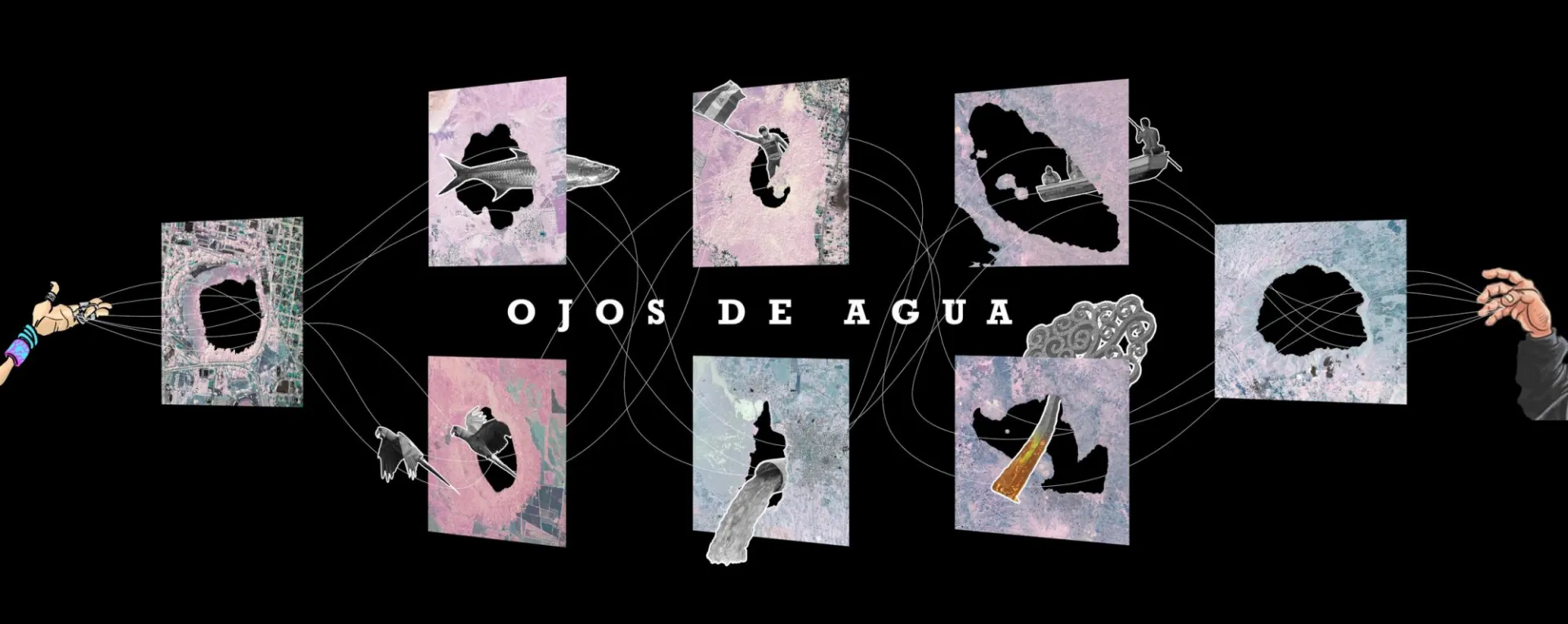
Ojos de Agua: Oscar M. Caballero
In recent weeks, I have undertaken a series of research projects taking Nicaragua's territorial dynamics as the main focus. In some cases, analyzing our natural resources, in others, remembering buildings and monuments that have been erased from our historical memory and finally reliving situations of injustice that have worsened since the socio-political crisis that we have experienced since April 2018 by the hands of the Ortega – Murillo regime.
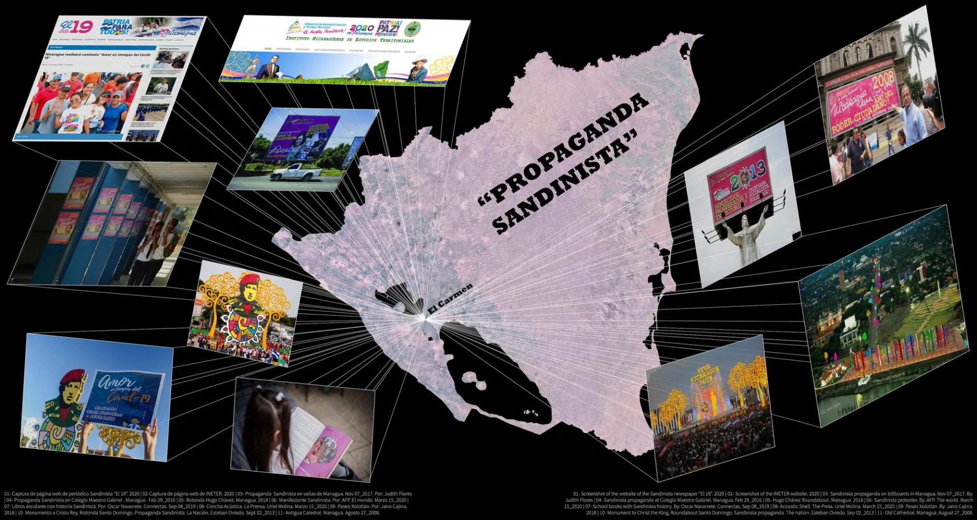
The history of Nicaragua is changing abruptly. Unfortunately, our academic resources are deteriorated, impoverished and even distorted by the current regime. The injection of propaganda by the Sandinista political party led by Daniel Ortega and under the yoke of Rosario Murillo, has completely infected any state resource in Nicaragua. In each logo, in each government website, on the streets, on buildings, in schools where children are indoctrinated and especially on television channels, we have been saturated by “Danielista” propaganda, as a method of clinging to power and establishing a dictatorial dynamic on information platforms.
This initiative arises with the intention of creating critical and independent material that covers issues of Nicaraguan relevance away from the propaganda that we have consumed for years. An architectural approach will be taken to analyze past and on-going situations in order to give sense to our current socio-political crisis.
This series of projects is presented as a compilation of graphic essays where I make use of architectural tools to create radiographic maps, collages, graphics with satellite images, etc. that synthesize information obtained from factual sources such as articles from national newspapers (not related to the current government) and international newspapers, studies by NGOs and International Universities that have arrived in Nicaragua in past years.
“Ojos de Agua” is the first study in this series where I explore some of the hydrological resources of the country. Beyond just being natural resources rich in flora and fauna with unique geographic, geological and hydrological properties, they also represent unspoken powerful geopolitical nodes that have shaped our demography, history, urban and rural memory, and economy.
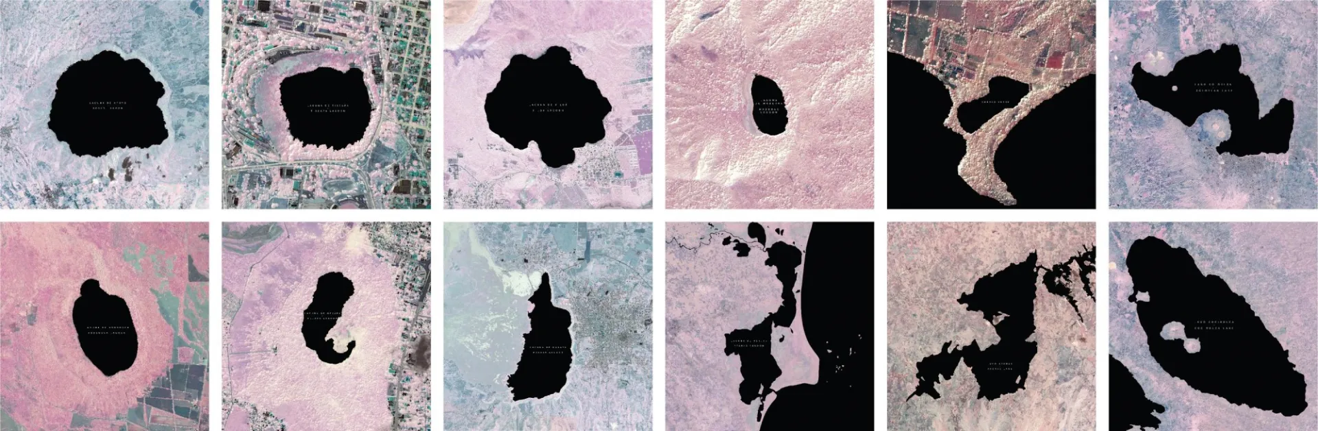
I started this project by asking myself: What is our relationship with our lakes and lagoons? How have they impacted our lives in Nicaragua? Being known as the land of lakes and volcanoes, one imagines that our territorial memory is impregnated in these natural elements that are so plenty and rich along our nation. However, our natural resources are also evidence of government mismanagement, territorial displacement, pollution and economic segregation. Many of these individual issues are part of the ingredients of the current situation in Nicaragua. Understanding our neglect and the decline of our natural resources is necessary to build the foundations of what can be retaken at some point in the future to raise awareness and develop better management plans for these resources that are actually fair and dignified for the Nicaraguan population.
Nicaragua has an inherent relationship with water. Although there is no exact translation of the Nahuatl language, different versions opt for translations such as: "land surrounded by water" or "Here by the water." The Pacific Ocean represents the western border and the Atlantic Ocean the eastern border of the country. The Nicaraguan territory has two great lakes (Cocibolca and Xolotlán), around 30 recognized lagoons of which at least 11 are of volcanic origin. Coastal lagoons, bays and an artificial lake are other hydrological resources of the country.
Each “ojo de agua” in Nicaragua is an agent of change and highly determinant in shaping the communities around them. Our relationship with the water resources of our urban and rural centers define part of our cultural identity and our relationship with nature. Much of the attraction and uniqueness of our volcanic lagoons are their endemic properties that have made our flora and fauna evolve in unprecedented ways. This effect transcends to our human dynamics and is reflected by seeing aerial views of the urban developments around these hydrological resources. Unfortunately, urbanization in areas surrounding lakes and lagoons has led to mistaken solutions like misuse of land, use of lagoons and lakes as garbage and human waste dumps and even (but rarely spoken) fake propaganda from Nicaraguan Governments that use the excuse of tourism to privatize natural areas that should be properly conserved and open to the public population rather than exploited by the private sector and foreign investors.
Ojos de agua are constellations that attract to their orbit a unique ecosystem, migratory animal species, human settlements, investments, tourism, international agents, political incentives, economic impacts, etc. It is because of this intersectionality of forces that these resources are geopolitical nodes that define a large part of our territorial dynamics.
APOYO LAGOON | NATURAL RESERVE OR TOURIST MONOPOLY?
Has really meant progress having so many hostels, businesses and private residences on the slopes of the Natural Reserve Apoyo Lagoon? Is this an image of progress or socio-economic segregation?
Tourism in Apoyo Lagoon has been a two-sided-story, a smokescreen that has been marketed as great works of progress by the Nicaraguan governments. The tourist monopoly in Apoyo Lagoon has been sold as something that stabilizes the country's economy when in reality has only privatized lands that should not be private; considering this area has been established as a natural reserve since 1991. The projects that are carried out in natural areas of Nicaragua cannot continue to be excused under the argument that they provide “jobs” for the community. The privatization of land in the Natural Reserve Apoyo Lagoon has only profited a very low percentage of the population. Owners of restaurants, hostels and private residences on the slopes of the reserve mostly belong to a specific sector of Nicaragua with a high social or foreign stratum or in some cases from close relationships with government forces. The real outcome of these unlawful activities is evident in the journey to the lagoon where communities are withdrawn from the lagoon. There is a high contrast between these communities that also have economic and infrastructural limitations and many of the new luxurious constructions on the shore and slope of the lagoon that, precisely because of their high cost, become inaccessible for most of the Nicaraguan population. A natural reserve should not be privatized and instead should be able to breathe from private tourism to open its resources to the communities around it.
The lack of regulations has directly influenced the architectural development of the area in which we see a clear social pyramidal hierarchy in the buildings that have populated the lagoon in previous decades and the native constructions with limited resources that have been relegated to adjacent areas. Despite some initiatives in past years to build public spaces on the area, there is much work to be done to balance the amount of private property that continues to appropriate the immediate shore of the Lagoon. It should also be contemplated a plan for public accessibility from urban centers to the shore of the Lagoon. Due to the lack of infrastructural plans and public spaces that are accessible and dignified, the population who want to visit the lagoon are conditioned to go to one of these private touristic places, since they have better conditions to enjoy this natural resource or sneak between informal trails to reach to a shore that has been appropriated by all these businesses around the Lagoon. As Nicaraguans we should be able to enjoy our own tourism at its best, a tourism that is suitable for everyone.
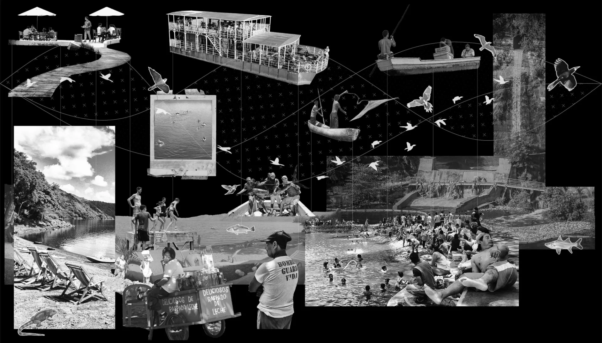
PEARLS LAGOON | LAGUNAR COMPLEX AND INFRASTRUCTURAL NETWORK
Laguna de Perlas is located in the Autonomous Region of the South Caribbean Coast of Nicaragua. It is the largest coastal lagoon in the country. In fact, Laguna de Perlas is not simply a lagoon, but a set of lagoons that interact with each other on this coastal edge that connects with several rivers in the area and empties into the Caribbean Sea.
This case study is totally different from Apoyo Lagoon where we saw abundant urban growth as part of the strategies of land privatization. Here, we find a rural area that has had little development in recent years. However, all the initiatives carried out in the Caribbean of Nicaragua were widely displayed and filled with propaganda by the Ortega Government as great works of progress. This situation would change later with the announcement of the interoceanic canal in 2014, increasing the abuses and injustices towards the inhabitants on the canal route that affected indirectly adjacent areas as well. This makes us wonder if the only interest of the Ortega Government in promoting tourism in the Caribbean was just another strategy to appropriate land and extract precious wood from the area. However, even long before the increase in corruption caused by this project, the Caribbean Coast has been one of the areas of Nicaragua where there has been more looting and corruption of natural resources by the hands of government forces and the private sector.
Unlike the Pacific region, the rural character of Pearls Lagoon has been used as a shield that makes it more difficult to expose situations of abuse and injustice. Part of this happens due to the lack of means and communication technologies, urban infrastructure and education. However, the same rural character has also been the reason for incredible evolutionary processes among humans, animals and plants. The lack of urbanity, transportation and land use has made the inhabitants of Pearls Lagoon turn it into an infrastructural network in itself. This water node brings together the most important economic activities in that area, where commercial and sport fishing supplies residences and businesses. Around the border of the lagoon there are few roads and some highways built in previous years. However, the lagoon provides the main transport conduit that allows better connections to islets and cays of the area.
Finally, Pearls Lagoon is also one of the epicenters of pile-dwellings on water in the country. Despite the fact that the Caribbean area is the region of the country most affected by tropical storms and hurricanes, its inhabitants have transcended the ground settlements to extend the architectural domain towards the waters of the lagoon. These informal and organic buildings are found on the shores of the aquatic mantle where communities have settled. Its execution is full of creative and empirical solutions that have become more sophisticated over the years. At this point, the floating architecture of Pearls Lagoon is one of the most interesting attractions in the region. The buildings have various typologies depending on their use. In some cases, gazebos anchored to a port, in others, buildings with a few volumes and in other cases more complex formations, composed of several volumes that offer a unique experience to the water and the views of the area.
Pearls Lagoon represents a node of intense commercial, tourist and residential activities. Its pronounced natural and architectural characteristics inform the territorial dynamics of the area that can be further studied to facilitate access to urban resources that do not interrupt the harmony that its inhabitants have built and kept for decades.
OJOS DE AGUA IN DANGER
Generations born in Nicaragua for the last three decades have grown knowing that our “Ojos de agua” are slowly dying. The excitement of visiting these incredible natural gifts gets to a bittersweet end once you learn that because of the wrongful urban planning conducted by Nicaraguan Governments, we are losing part of the greatness of our land. It has become a systematic problem, deep-rooted in our culture and lifestyle. The Ortega-Murillo regime uses their propaganda to present an intention of change. They have carried out what looks like projects that are meant to save some of these resources like the Sanitation Project in Lake Xolotlán (2012) and the Oxygenation Project in Tiscapa Lagoon (2019). The failure of these projects has been evident in a short time, simply because they approach this issue from the wrong angle. There cannot be a plan to sanitize our water resources is they don’t include a change in the planning of our urban settlements, the wrongful rainwater urban infrastructure with sewers that continue to pollute these resources and finally, but most importantly, we cannot save our lakes and lagoons if we don’t change our human culture. This last item is problematic for the current regime because it involves education. In order to create real change in our country we need to empower our communities with access to good free education. The Ortega-Murillo regime is aware of this and that’s precisely why they have hacked and infected the education system with their fake propaganda. There cannot be a significant change in Nicaragua, if the population doesn't change their mindset. What is the purpose of cleaning the lakes and lagoons? If the lack of education and proper infrastructure keeps polluting them? Each element is interconnected. The problem is that empowering the Nicaraguan population would mean the end of their dictatorship.
To see the full graphic essay, click here.